


Land 2024, 13(4), 546; https://doi.org/10.3390/land13040546 (registering DOI) - 19 Apr 2024
Abstract
In croplands, soil erosion resistance varies with both natural processes and human disturbances. To clarify the temporal variation in soil erosion resistance, nine cropland plots with three treatments (continuous fallow, fallow after tillage and tillage with corn) were established in the dry–hot valley
[...] Read more.
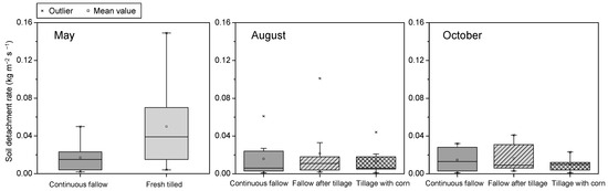
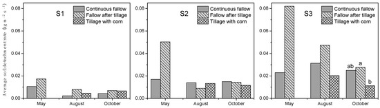
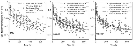
In croplands, soil erosion resistance varies with both natural processes and human disturbances. To clarify the temporal variation in soil erosion resistance, nine cropland plots with three treatments (continuous fallow, fallow after tillage and tillage with corn) were established in the dry–hot valley region of China. A total of 144 field runoff simulation experiments were conducted from May to October to measure the soil detachment rate (Dc), rill erodibility (Kr) and critical shear stress (τc). The results revealed that the natural dry—wet alternation had little influence on the continuous-fallowed soil erosion resistance. On the other hand, the tillage disturbance that occurred in May sharply increased the Dc and Kr to 2.24 and 3 times that of the continuous-fallow treatment, respectively. Then, the erosion resistance could be enhanced with surface consolidation for the fallow-after-tillage treatment. However, after three months of fallow, the Kr was still 89.5% of the fresh tilled soil. In contrast, crop growth could significantly improve aggregate stability and reduce the Kr to 38.2% in August and even further to 23.7% in October compared to the fresh tilled soil. It could be concluded that crop growth is more efficient in enhancing erosion resistance than the mechanical effect. The above results would benefit from the accurate modeling of cropland soil erosion dynamics and guide agricultural management in dry–hot climate regions.
Full article
(This article belongs to the Section Soil-Sediment-Water Systems)
►
Show Figures
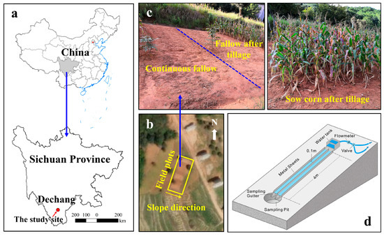
Figure 1


